
NEW: Onshore Inspections
The Flux
A robust handheld system for corrosion detection and 3D mapping of unpiggable pipelines.
Discover the Flux
Inspect The Unpiggable
NEW: Onshore Inspections
A robust handheld system for corrosion detection and 3D mapping of unpiggable pipelines.
Discover the Flux →
NEW Service
Know how fast every coating defect corrodes, in µm/year, validated against excavations.
See how it works →
FREE: Whitepaper
How CMI separates protected steel from actively corroding steel, without excavation.
Download →A pipeline river crossing is the section where a pipeline passes under a river or another body of water. The pipe lies below the riverbed, and the cover above it is its protection. Floods, scour and a migrating channel can remove that cover and expose the pipe to the current. US regulators have addressed the subject in repeated advisory bulletins, and crossings are among the sections that are hardest to inspect.
On this page
At a glanceRisksInspectionWith CMIFAQ
| Threats | Flooding, river scour and channel migration, which remove the cover and can expose the pipe |
| Consequence of exposure | Current forces, debris and vibration act on the free span |
| US rule for liquid lines | Crossings under navigable waterways are inspected at intervals of no more than 5 years, under 49 CFR 195.412 |
| Classic inspection | Depth of cover surveys, bathymetry, divers |
| Why difficult | Water depth, current and visibility, and not every crossing can be pigged |
| With CMI | Survey by boat from the water surface: depth of cover, 3D profile of pipe and riverbed, corrosion risk |
Severe flooding, river scour and channel migration can damage a pipeline, and PHMSA has addressed them in several advisory bulletins. In one failure described there, channel migration and scour of the river bottom left a large span of the pipeline exposed to the current and to debris, and these forces damaged the pipe. In another, a 6-inch line was exposed by scouring during extreme flooding.
An exposed span can also start to vibrate in the current. One failure described in the bulletins was fatigue crack growth driven by vibration from vortex shedding.
The bulletins advise operators to survey the depth of cover and the condition of any exposed pipe after flooding.
The position of the pipe is the missing piece. A survey of the riverbed only shows the cover if the position of the pipe below it is known.
EMPIT's Current Magnetometry Inspection (CMI) surveys water crossings by boat. The inspection current flows in the pipeline, and the sensors measure its magnetic field from the water surface. EMPIT uses an autonomous inspection boat built for inland, nearshore and coastal waters with depths of up to 50 m.
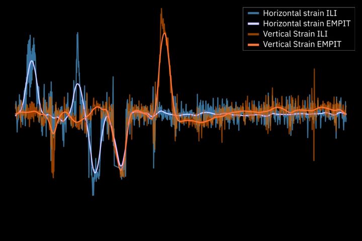
The survey records the corrosion risk, a 3D profile of pipeline and riverbed, and the depth of cover below the water. From the 3D position, the bending strain is derived.
At a river crossing in California, EMPIT inspected parallel pipelines by boat together with PG&E. Bathymetric surveys had projected exposed pipe, dive inspections stayed incomplete in adverse water conditions, and in-line inspection was not possible on one line. See Bending Strain on Unpiggable Pipelines.
Where a crossing is deeper or further offshore, a CMI-guided ROV takes over. See the first CMI-guided ROV.
The removal of riverbed material by flowing water. At a crossing it reduces the cover above the pipeline and can expose the pipe.
For hazardous liquid pipelines in the United States, each crossing under a navigable waterway has to be inspected at intervals of no more than 5 years to determine its condition.
Yes. CMI surveys the crossing by boat from the water surface and delivers the depth of cover, a 3D profile of pipe and riverbed and the corrosion risk.
The free span is loaded by the current and by debris and can start to vibrate. Failures of exposed crossings are described in PHMSA advisory bulletins.
If you want to know what an above-ground inspection would show on your line, send us the length, diameter and location of the pipeline. We will tell you whether CMI fits and what a pilot section would look like.
Sources
Related terms
Depth of CoverGeotechnical HazardsBending StrainPipeline MovementUnpiggable PipelineDrone InspectionPipeline Rupture
Read more
21. November 2026
We use cookies to give you the best possible experience on our website and to improve our communication with you. We only use the data for which you have given us your consent, with the exception of the cookies that are absolutely necessary for the functionality of this website. For more information, please see our privacy policy. Make your choice here:
You can change your consent at any time by clicking on the Cookie Settings link in your footer.
Protects against cross-site request forgery attacks.
Saves the current PHP session.
Cookie from Google for website analytics. Generates statistical data about how visitors use the website. https://policies.google.com/privacy?hl=de